1. Index number
Charts are sequenced alphabetical or by runway number within similar type arrivals or departures.
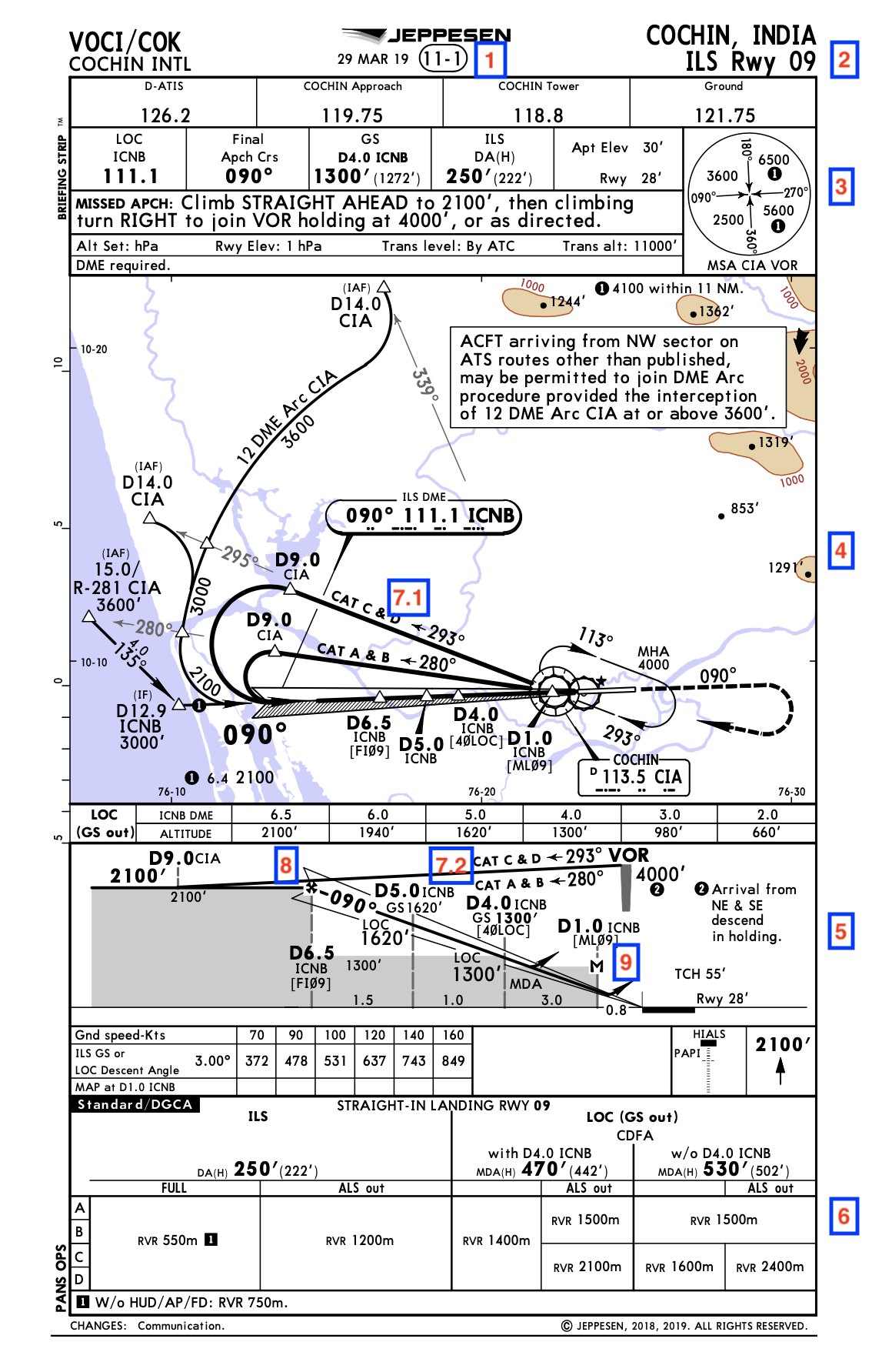
Frequently, there are many airports listed under one city name. In order to keep the sorting system straight in your Airway Manual, Jeppesen uses an index number which is at the top of every approach chart. This index number is usually a three- or four-digit number enclosed in an oval at the top of each chart. This index number helps to sort airports within city names and it also helps to sort the approaches in proper sequence at each airport. The first digit is used to sequence airports under a single city name.
For example: The first number “1” in the index number “11-1” at Denver is used for Denver International Airport, the principal airport. All approach charts for Denver International have an index number beginning with the number “1.” Jeffco Airport is listed as the second airport under Denver and has an index number of “21-1.” Buckley Air National Guard Base is the third airport listed under Denver and uses the index number “31-1.” (The name Buckley is above Aurora, a suburb of Denver, since this is an approach chart supplied only to subscribers of the military approach chart series.) Centennial Airport is the fourth airport that is listed under Denver and has the index number “41-1.”
The first number is arbitrarily chosen and doesn’t necessarily indicate a descending order of airport capability. The second number within the index oval is also used for sorting, but the number has a bit more significance from a pilot perspective. The approach with the greatest precision and the lowest minimums usually has a lower index number than the approaches with higher minimums. As an example, at Denver International Airport the second digit “1” in the “11-1” index number is used for ILS approaches. By using this system, the “best” approaches are found at the beginning of each airport listing. As you flip the pages for each airport, you will notice the minimums usually go higher. The following numbers represent the type of approaches that will be found according to the second digit of the index number:
0 — Area, SID (DP), STAR, Taxiway
Facilities, Class B Airspace, etc.
1 — ILS, MLS, LOC, LDA, SDF
2 — Reserved
3 — VOR
4 — TACAN
5 — Reserved (Formerly Low
Frequency Range)
6 — NDB (ADF)
7 — DF
8 — GPS, PAR, ASR, SRA, SRE
9 — VOR DME RNAV, Vicinity Charts, Visual
Arrival, Visual Departure
The number “0,” when used as the second digit, applies to non-approach charts included with each city. The Denver Area Chart uses a second digit “0” followed by “-1.” The third digit in the “10” series indicates the type of chart. The “-1” is used for area charts, the “-1A” is used for Class B Airspace charts, the “-2” is used for STAR charts and the “-3” is used for DP or SID charts.
When more than one of the same type of approach is found at an airport, the first two numbers of the index are the same. To provide proper sequencing of the charts, the third digit becomes significant. As an example, the first chart for Denver International is “11-1” for the ILS Rwy 7 approach. The index “11-2” is for the ILS Rwy 8 approach and the index “11-3” is for the ILS Rwy 16 approach. Within a type of procedure, such as the ILS, the approach charts are being changed to be sequenced by runway number so it is easier to find a specific approach at a larger airport.
ATPL VIVA QUESTIONS
AWAIT ANSWER
ATPL VIVA QUESTIONS
AWAIT ANSWER
ATPL VIVA QUESTIONS
AWAIT ANSWER